By: John Bishop, Jr.
Have you ever wondered if you live in the FEMA Floodplain or if you are vulnerable to sea level rise? Maybe you are curious about what kind of coastal habitats are in your backyard.
If so, there’s a website with all of this information in one place!
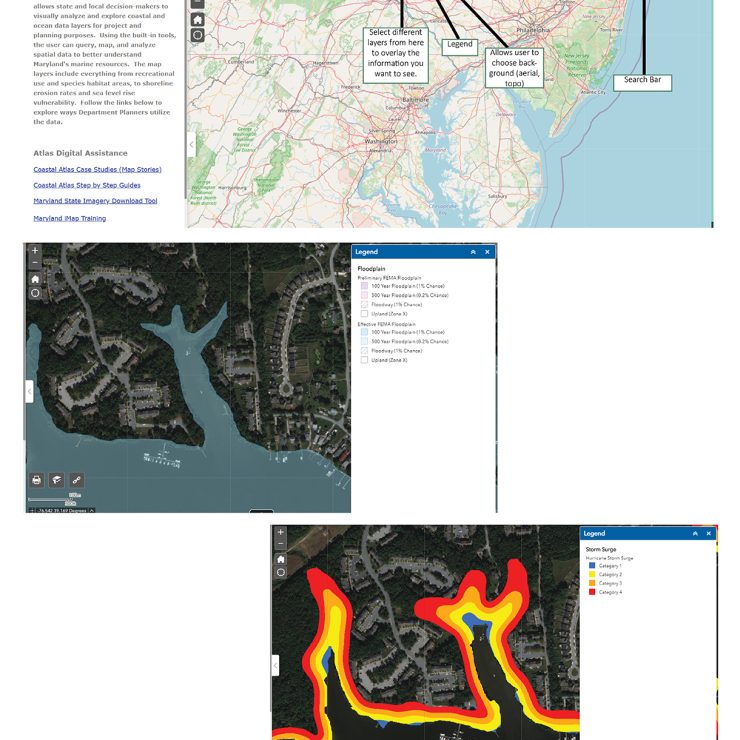
Check out Maryland’s Department of Natural Resources (DNR) website the Coastal Atlas: https://gisapps.dnr.state.md.us/coastalatlas/WAB2/. The Coastal Atlas is a geographic information system (GIS) mapping tool that you can use to “visually analyze and explore coastal and ocean data layers.” The layers range from recreational use and species habitat areas to shoreline erosion rates and sea level rise vulnerability.
You can investigate the diversity of fish near you, search for the closest Public Shellfishery, or analyze model results of areas at risk of storm tide flooding from hurricanes.
At Straughan, we use this comprehensive tool in many ways on our projects. When we are doing desktop assessments of a shoreline stabilization site, the Coastal Atlas provides us access to so much relevant information in one place. We will reference the Shoreline Inventory and Rates of Change layers to get an idea of existing infrastructure/resources at the site or how the shoreline is evolving over time. Coastal Atlas also has natural resource layers that provide background on Submerged Aquatic Vegetation (SAV) or other sensitive habitats. There are also a number of planning layers that can be referenced to locate regional assessments. One example, the 2016 Coastal Resiliency Assessment, identified priority restoration and conservation areas that would enhance coastal resiliency and reduce risk to communities impacted by inundation, erosion and other coastal hazard impacts.
Whether you are performing desktop assessments like us or just curious about the shoreline near your house, take some time to check out the wealth of information on DNR’s Coastal Atlas. Let us know what you find!
